If you have ever dreamed of sailing to the top of the world, then cruising to Hammerfest Norway can make that dream come true. Hammerfest is the northernmost town in the world situated at 70 degrees north and located in the heart of Northern Norway. It is also the oldest town established July 17, 1789.
The first settlements appeared in Hammerfest between 1250 and 1350. To encourage trade and to establish a town, Hammerfest was granted municipal status in 1789. People taking up residence were given free building plots and allowed to run businesses without paying taxes for 20 years. As a result, the population grew from 77 in 1801 to 1,500 by 1850.
Unfortunately, the old Hammerfest was burned to the ground during the second world war. The rebuilding process took place in the years to follow. With less than ten thousand inhabitants, Hammerfest is a rather small town but despite the size, the town has varied trade and industry with fishing, tourism and petroleum as the most important. Its rich history also includes being the first European town to install electric street lamps.
Hammerfest is most known for having the best ice-free harbor in northern waters. Since 1884 Hammerfest has also been the pioneer town in Norway for the development of deep-sea fishing for Greenland shark.

Greenland Shark Photo: Public Domain
The
Norwegian Star docked
in Hammerfest Norway on Wednesday June 14, 2023 at 8:30am. The weather forecast for the day in Hammerfest
was high of 50 degrees and cloudy.

Norwegian Star docked in Hammerfest
I
had several items on my ‘to do’ list. Namely,
ride the local bus, visit the Hammerfest Church, the Royal and Ancient Polar Bear Society Museum,
Salen Hill lookout and the Meridian Column.
By 9:30am I stepped off the ship and was ready for a day of exploration.

L-R: Marci Inman, Sharon Sparlin
MERIDIAN COLUMN
The Meridian Column is a very short and easy walk from the dock. It sits on a slight rise with a wonderful view of the town and the ocean. Be sure to follow the directions on the map below as turning left out of the port will dead-end at a locked gate.
The base of the monument sits in the middle of a cobblestone circle. The column rests on a base made of polished marble and carries a gold inlay inscription – Latin on one side and Norwegian on the other. The latitude position of 70°40'11.3" is included in the inscription .
The column has a square top with small knobs that point towards all four cardinal points. On top of the square there is a globe with a pin at its top, which symbolizes the town Hammerfest. Both the top square and the globe are made of bronze, which has turned green with age. The entire monument has a height just over 13 feet. This column commemorates the first official measurement of the earth’s circumference, better known as the Struve Geodetic Arc.
On the left side of the stonewall there is a plaque on which one can read the history of the monument in 4 different languages: Norwegian, English, German and Finnish. The English text reads:
The Meridian Column
“The Meridian Column was raised to commemorate the first international measurement of the earth. Between 1816 and 1814 (an engraved typo! It should be 1840), the astronomer W. von Stuve (a typo, the name should read Struve) took measurements along a meridian in Russia. In 1844 he proposed to King Oscar I of Norway and Sweden that the two countries should join the Russian effort and complete the measurement from points as far north and south as possible. The measurements were concluded in Hammerfest in 1852. The distance measured was approx. 2000 kilometres. The memorial column was raised by King Oscar II.”
It certainly seems like a pretty modest monument to remember one of the biggest scientific tasks in the world - that of measuring the planet itself. It marks the start of a 2,820 km/1,752 mi arc, aka Struve Geodetic Arc, that ends in the Black Sea.
“Friedrich Georg Wilhelm von Struve (1793–1864), the German geophysicist who was the director of the stellar observatory at the University of Dorpat in Russia (now Tartu in Estonia) began work on mapping the exact shape and size of the planet in 1816. In his work, von Struve used 265 measurement points – triangulation points – that form a 2,820 km/1,752 mile-long arc from Finnmark to the Danube Delta, known as the Struve Geodetic Arc."
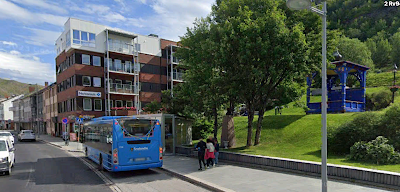
Now it was time to ride a local bus. I boarded bus #130 from the port. The closest stop is ISBJORNHALLEN HAMMERFEST VGS. From here I headed to the city center and got off at the OLE OLSEN’S PLASS stop. A senior 24-hour bus pass was 30NOK or $2.98USD at the time of this writing and I paid the driver using my credit card.

Ole Olsen's Plass bus stop in city center
At the OLE OLSEN’S PLASS stop I boarded bus #132 and headed to the northern village of FORSOL. This bus made a stop at quick stop at HAMMERFEST LUFTHAVN, the airport. I left the city center at 11:32am and arrived FORSOL at 11:50am. The distance is only 4.3 miles.
I did not spend time in FORSOL, rather I remained on the bus and returned back to the city center, arriving at 12:15p.
HAMMERFEST CHURCH
From the OLE OLSEN'S PASS bus stop you can walk to the Hammerfest Church. My GPS indicated about 400 meters and it would take 5 minutes.
The first simple wooden church was built in Hammerfest in 1620 but over the next 340 years it was renovated several times, torn down and rebuilt in it's entirety and even burned to the ground in 1944 by the retreating German Army. The current white concrete church is relatively new as far as churches in Norway goes, built in 1961 and seating 525.
SALEN HILL
For fantastic panoramic views over the town, coast and mountains you can climb Salen Hill to the lookout. The 15-minute uphill walking trail begins at the small park behind the Rådhus.
You will know you are in the right place when you see this bright blue gazebo.
Right in front of the gazebo is the Ole Olsen Stone.
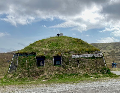
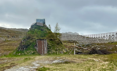
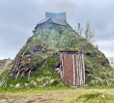
The climb up Salen Hill to the viewpoint is 86 m/282 feet and there's a free pair of binoculars available at the top. Along with the viewpoint there is the Turistua Restaurant and a couple of Sami turf huts.
Instead of hiking up to the viewpoint, I decided to take the bus, picking up bus #131 at the OLE OLSEN’S PLASS bus stop. The stop for the Salen Hill viewpoint is HOYDEN bus stop.
 |
| Sami Turf huts on walk from bus stop to viewpoint |
 |
| View from Salen Hill viewpoint |
I took bus #131 back to the center of town, getting off again at the OLE OLSEN’S PLASS stop. I then walked to the Royal and Arctic Polar Bear SocietyMuseum.
ROYAL AND ARCTIC POLAR BEAR SOCIETY MUSEUM
The Polar Bear is the town mascot of Hammersfest. In the museum are a variety of mementos of the early life of Hammerfest, including a profusion of stuffed animals, early Arctic hunting, traveling and camping equipment, and a gallery of photographs, paintings, drawings and writings of, and from, the town's history.
Founded in 1963 by two local businessmen, the Royal and Arctic Polar Bear Society Museum, simply called the Polar Bear Club by locals, is not particularly old. Primarily, it is a somewhat jokey feature for tourists. Entrance to the actual exhibition is free of charge but visitors are encouraged to join “The Society” which is confirmed with a membership pack, the contents of which include a certificate signed by the mayor, a sticker, a membership card and a lapel pin made of silver and enamel. Since the only way to join “The Society” is in person at the Polar Bear Society, the pin signifies proof of your visit to this remote part of the world.
Before heading back to the ship I made a stop at Kaikantan Bar for a local beer. The cost was 86NOK or $8.54USD.
I felt like I had walked 4 or 5 miles but my step meter indicated only 6,664 steps for 2.7 miles.


No comments:
Post a Comment